Climb to the Summit of Folding Mountain

The hike / climb up Folding Mountain on Aug. 10, 2010 turned out to be both challenging (especially during the tough first 2 kms that involved a steep elevation gain) and thoroughly delightful once most of the elevation was gained and the walks through the alpine meadows began.
This trek was on my wish list for a long, long time. I remember a co-worker at MacEwan mentioning he’d gone hiking with a buddy and that they’d had a lot of trouble finding the trailhead. Then a year or so later I happened to be reading the logs of geocaches I’d like to do someday and saw the cache owner had a picture of a log book signed by “non-cachers” – none other than my MacEwan co-worker and his buddy. So this is where they’d gone. I wanted to go too!
I had another more selfish reason for wanting to do the hike up Folding Mountain: there were two caches with the same Difficulty / Terrain rating, a combination I needed to fill my “Difficulty / Terrain” matrix, a goal I’d been working on since Dec. 09. I needed either of those caches to fill that spot on my chart.
After spending the night in Hinton, I arrived at about 8:00 am the parking spot near the trailhead (both of which I’d scouted out the day before while caching in the area). Then the long, hard slog up the first section trail began. The UP was relentless, with an early start I knew I had lots to time to get as far as I could during the day and get back again. The first cache I found along trail was named HTEG Micro (“Half the Elevation Gained”). I wrote in the find log afterward that I’d mentally renamed this cache AATLJG (Almost All The Leg Juice Gone). But once I’d gotten there and found that well camo’d cache, there was still elevation but somehow it didn’t seem so bad.
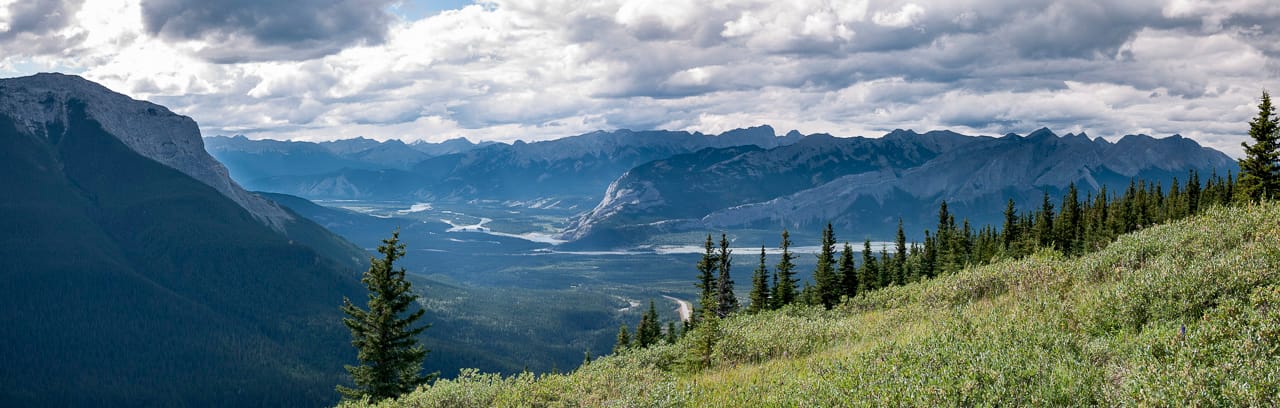
Once I made my way up a little more, I could start to see south across Highway 16 to the Athabasca River. At this point the views were filled with dark clouds and a light mist was falling, making me worried that if the weather worsened I’d have to retreat and try this ascent another day. Luckily, as the day wore on, the bad weather simply blew past and left vegetation green and glistening with water in the sunlight.

It was a refreshing sight, but the problem was the water on the bushes and grasses along the trail was splashing onto my legs, running down through my socks and actually filling my boots with water. If there was ever a time for gaiters, this was it, but alas I didn’t have any with me. By the time I’d found a cache that required me to project a waypoint from a certain set of rocks — and it took me BACK along the trail I’d just hiked and UP for little bit again — I was ready to dump the water from my boots and wring out my socks. From then on, I could walk properly without squishing at every step.
Gradually, I made my way to find six of the seven caches along the way, including the two that had the D/T combination I needed. Then came the summit and as I neared it, well, it looked foreboding. From here on, I think I’ll just let what I wrote in the online log for the summit cache tell the story:

The summit. There it sits in its almost naked grandeur. I’d seen the various log pictures, and played the climbing movie in my brain beforehand, but, as usual, the actual experience was different than the movies. The actual climbing to the summit was a real challenge for me and I’m proud of myself for having done it. When one gets closer and closer, the quiet summit gets a little more intimidating with each step toward it, until you kind of hurt your neck because of the extreme angle while peering up as you find the trail on the way up. Little mantras did help me on the way though, like (since I’d gotten a fairly early start) “I’ve got all day”; “ One step at a time” was useful, but actually there was more like 10m between my rest breaks; and also popular, just so I wouldn’t have to look the thing in the face anymore, was “Don’t look up!
When I reached the top (Halleluiah!), and suddenly spied the summit cairn, I only had the energy to let out two sounds: “Ha – Ha”; that was all I had the energy for, and then I had to have a rest, at least for a few minutes.
After that, not paying any attention to my GPSr at this point, I immediately spied a container nestled in the rocks of the summit cairn. Given the cache name, I just assumed these were the goods. After uncovering and opening the plastic container, I found only a large hollowed out book with some paper inside. The only signatures were from what looked like a church (?) group of I guessed were mostly teenagers (?) and dated August 5, 2010, just five days ago. My sleuthing powers were at their peak when I said out loud, “This is not a geocache!” They don’t call me the Master of the Obvious for nothing! After fetching my GPSr I realized the cache was a little ways away and made my way over to make a quick find in the well-chosen spot and it was a thrill to find the cache as a kind of tangible symbol to acknowledge the hard work it had taken to get to the summit.
After re-hiding the cache best I could in the same way I’d found it, I had lunch and explored the area and took in the 360 degree views. What a great spot, with so much character. To the west in the foreground it looks hard and sharp, but to the south it looks, in this season anyway, soft, with subtle green slopes. To the east simply vast, with views of the Hinton area and beyond. I lingered for quite a while, and didn’t want to leave, so just continued to take in the view and take pictures. Making my way down was faster, but required much more focus than ascending. I’d been happy to be at the top, but now it was also comforting to make my way to what seemed like solid ground on the trail below.
I made my way more along the trail more quickly, of course, because elevation wasn’t a factor, but the toes really did hurt quite a bit once I finally reached the highway and heard what seemed like the sweet sounds of cars whizzing by to and from Jasper.
Civilization again, now with a fresh glow of accomplishment to make it seem better.
Photo Gallery


My Track
[lfh-gpx src=https://grantstracks.com/wp-content/uploads/Folding-Mountain-Hike-Aug-10-10.gpx color=darkgreen width=6]Hike to Basecamp Cache at Birch Lake Isle[/lfh-gpx]


