Blackfoot Islet Lake Hike for “Cigar” Caches
Okay, I knew it was going to be a long hike. I knew that. But knowing is only a mental concept until you actually do it. It still surprises me that this hike added up to 22 km and took me 5 hrs twenty minutes to do, 4 hrs moving, and 1 hour and 20 minutes stopped either resting, taking pictures or checking on others’ caches.
My goal as I started out from the Islet Lake Staging Area in Blackfoot on a holiday (for me) Monday was two caches hidden by Kickbuttedmonton an Edmonton cacher who usually works in the word “Cigar” into his cache titles because, well, he likes cigars I guess! The first cache was in relatively easy walking distance, but the second one, well that one wasn’t. It was hidden at the northernmost edge of Blackfoot where the recreational area borders Elk Island National Park. It was going to be a long walk to that one.
A November 15 without snow; that was a treat. All the same, the cool winds of November blowing today were like the “advance team” for an old man winter who was certainly not far behind. Even though I’d pretty much just returned from a hiking trip in Kananaskis two days ago, I knew I had to go for these caches before the snow came wafting down. Otherwise those pesky cache symbols – and not smilies (what the map shows once you’ve logged a cache as found) – would be staring me in the face the entire winter. I just couldn’t have that! 🙂
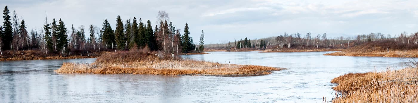
I started out on the hike feeling strong and had a nice walking rhythm early. The Islet Lake trails are really interesting since one starts beside a beautiful lake dotted with little islands. I’ve been to this area enough to say I’ve been able to witness the same ground with quite a few different characters: foggy, sunny and now, well, November-y.
Blackfoot-HIke-for-Cigar-Caches-037-610×343.jpg
I quickly made my way to the first cache which was hidden at one of the many huts placed strategically throughout the rec area. After the making the find, I noticed that the logbook, an official geocaching logbook ordered from the website, was actually a German version. This prompted me to try to dredge up my German from years past and write part of my log in German. It was fun and frustrating at the same time, since I had to strain a bit to remember spelling (which in German is usually very easy – unlike English, in German, if you can say it, you can spell it – that’s so darn practical and logical!).

After re-hiding the cache, I steeled myself for the long, long next phase to the second cache. The trail took me to Push Lake Shelter where I was thankful to make use of the facilities and took a few pics. Then I scaled a couple of fences and was on my way north on a road called N.U.L. North. I guess I must be losing my Sask. roots a bit because walking that long straight, featureless road became a tad boring.
I was able to break the monotony by looking in on a cache called “Highest Point” because, not coincidentally, this spot is the highest point of elevation in Blackfoot. I didn’t have the coordinates to the cache and was just going on memory of the time I first found the cache with my friend Amy on Nov. 10, 2007 a little more than 3 years ago. Well after rolling commando style under the fence, I walked over to where I thought it was, experienced a strong bout of deja vu and literally found it in 20 seconds. The ammo box looked fine the way it was, so I didn’t open it, just put another nearby log over top to keep it snug for the winter months.

The next stop was another cache I’d found before, another by Kickbuttedmonton. This one wasn’t so healthy and I spent some time fixing it up, finding some better cover for it and adding some paper from a notebook I was carrying because the logbook seemed to have mysteriously disappeared. Now that I think about, that probably made up a good 20 minutes of my “stopped time” noted above.
The road’s gummy soil was sticking to my shoes in the intermittent spitting rain (mixed with at least a few snowflakes) so I was glad to dip onto Wapiti trail for the rest of the walk to the second cache. That trail is used by equestrians so it too was worked up and sticky in places, but on the whole was a nice change from the long, straight road.
Along this leg I was really struck with the amount of beaver activity in the area. I had chuckle when I saw a completely chewed tree which normally would have been a fallen trophy for the beaver, but had only fallen into the branches of its neighbour which were still holding it up. I could just see the beaver having to call back the contractor on that one!
At another spot beaver had fallen a huge tree which was partly obstructing the trail. I took some pics and had fun composing captions for them. There’s time to think about these kinds of things during a long, long hike.
I finally made it to the cache site and made the find pretty quickly; it wasn’t meant to be a hard hide. Then I just sat and ate a hiking power bar and drank a good bit of water. Lookin at my GPSr, I saw I’d just walked 11 km to get here. Now I had to get back! I had joked in the cache log that I’d just wait for the helicopter I’d ordered, but the hard truth was that I had to walk all the way back now.
I decided to take what looked like a longer but much more scenic route back, mostly along trails I’d walked before during past hikes. I took Wapiti back to Winter trail and followed that for 2.4 km until it met up with Lost Lake trail which is a long, long trail that spans a good part of the rec area. Whenever I’d get to a trail intersection, I would feel I’d accomplished something, smile and then continue on, trying to keep a good pace because the clouded sky was losing the light fast.
On the way along Lost Lake trail I checked in on one of my own caches, one which has been reported as being found right out in the open a few times: no doubt due to some frisky coyotes using it as a play toy. On this my first maintenance visit to the cache, I found it snugly hidden away by some conscientious finders and I’m thankful that they hid it so well.

I took Push Lake trail on last leg back to Islet Lake and by this time I really could feel that my little toe of my right foot was hurting. Later I found a small blister on it, but since that was the only real indication on my feet of such a log walk, I really don’t have too much to complain about.
Blackfoot staging areas all have signs at 400 meters away from the trailhead which tell seasonal hunters there’s no discharging any closer to the staging area parking. After such a long walk, to a non-hunter like me, seeing those sign is like a gift from heaven. It means I’m close to being able to rest and recuperate. As I walked by the sign I smiled a broad smile and was actually quite proud I’d been able to keep up the pace on leg after leg of this hike and return tired, sure, but pretty much unscathed from the trek.
I honestly think it’s such a privilege to be able to walk safely, in solitude in such naturally wild places.


