West Highland Way - A Sample of the Waymarkers Along the Way
West Highland Way - 2026 - This article is part of a series.
The West Highland Way is a very well-marked trail, and as I walked it from April 6 to April 12, 2026, I often tried to capture waymarkers that caught my eye as I went.
The route was first established in 1980, and of course, the installation and maintenance of waymarkers has gradually taken place over the forty-odd years since then. There are various styles; some markers seem new and shiny, and others have succumbed to the sometimes harsh elements that have battered them over the years.
Here’s a sample of the waymarkers I happened to notice during my West Highland Way trek.
Day 1#
(Click to see a larger version)

Day 1 - This is one of the first markers I came across about 10 mins after starting out.
Camera Model: iPhone 15 Pro
Click for Map Location:N 55.9453528 W 4.3214667
Day 1 - This is one of the first markers I came across about 10 mins after starting out.

Day 1 - Close to Glengoyne Distillery, not far from the Beech Tree Cafe Bar.
Camera Model: RICOH GR IIIx
Click for Map Location:N 56.0143944 W 4.3694500
Day 1 - Close to Glengoyne Distillery, not far from the Beech Tree Cafe Bar.
Day 2#
(Click to see a larger version)

Day 2 - Signpost to mark where the Rob Roy Way meets the West Highland Way.
Camera Model: RICOH GR IIIx
Click for Map Location:N 56.0843806 W 4.4441056
Day 2 - Signpost to mark where the Rob Roy Way meets the West Highland Way.

Day 2 - I love this one! Its got character. Imagine how many people it has guided over the years!
Camera Model: RICOH GR IIIx
Click for Map Location:N 56.0843194 W 4.4441056
Day 2 - I love this one! Its got character. Imagine how many people it has guided over the years!
Day 3#
(Click to see a larger version)

Day 3 - Along the tamer section on the shores of Loch Lomond.
Camera Model: RICOH GR IIIx
Click for Map Location:N 56.2039750 W 4.6792750
Day 3 - Along the tamer section on the shores of Loch Lomond.

Day 3 - Just south of the Inversnaid Hotel on Loch Lomond. This one has seen better days.
Camera Model: RICOH GR IIIx
Click for Map Location:N 56.2418806 W 4.6843611
Day 3 - Just south of the Inversnaid Hotel on Loch Lomond. This one has seen better days.

Day 3 - North of the Inversnaid Hotel on Loch Lomond.
Camera Model: RICOH GR IIIx
Click for Map Location:N 56.2479028 W 4.6871722
Day 3 - North of the Inversnaid Hotel on Loch Lomond.
Day 4#
(Click to see a larger version)
Day 4 - Transitioning from a single track to a small road near the River Falloch.
Camera Model: iPhone 15 Pro
Click for Map Location:N 56.3693389 W 4.6580639
Day 4 - Transitioning from a single track to a small road near the River Falloch.

Day 4 - This sturdy marker is part way through a forested area west of Crainlarich.
Camera Model: iPhone 15 Pro
Click for Map Location:N 56.4045833 W 4.6559556
Day 4 - This sturdy marker is part way through a forested area west of Crainlarich.

Day 4 - South of Tyndrum, this one is returning to the earth, but still doing its job.
Camera Model: iPhone 15 Pro
Click for Map Location:N 56.4226861 W 4.6784417
Day 4 - South of Tyndrum, this one is returning to the earth, but still doing its job.
Day 6#
(Click to see a larger version)

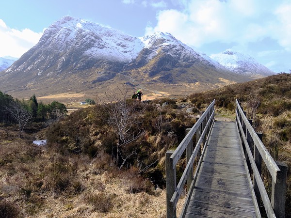
Day 6 - A marker at the bridge over the Etive River at Kingshouse Hotel.
Camera Model: iPhone 15 Pro
Click for Map Location:N 56.6515611 W 4.8402722
Day 6 - A marker at the bridge over the Etive River at Kingshouse Hotel.

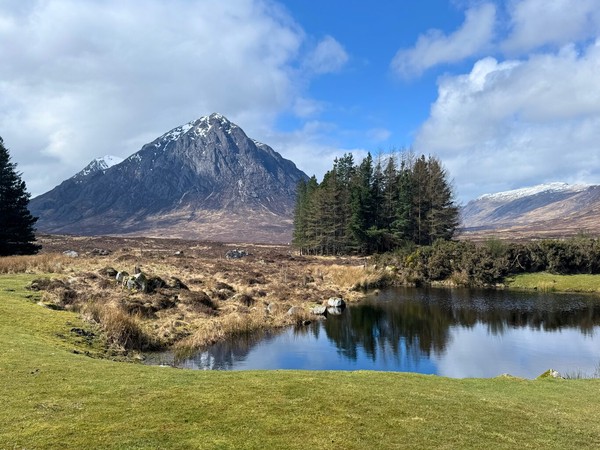
Day 6 - An iconic marker on the way west from Kingshouse Hotel. That's the much-photographed Buachaille Etive Mòr mountain background left.
Camera Model: iPhone 15 Pro
Click for Map Location:N 56.6538222 W 4.8553528
Day 6 - An iconic marker on the way west from Kingshouse Hotel. That's the much-photographed Buachaille Etive Mòr mountain background left.

Day 6 - This marker guides the hiker onto an old military road which leads to the Devils Staircase.
Camera Model: iPhone 15 Pro
Click for Map Location:N 56.6539222 W 4.8553944
Day 6 - This marker guides the hiker onto an old military road which leads to the Devils Staircase.

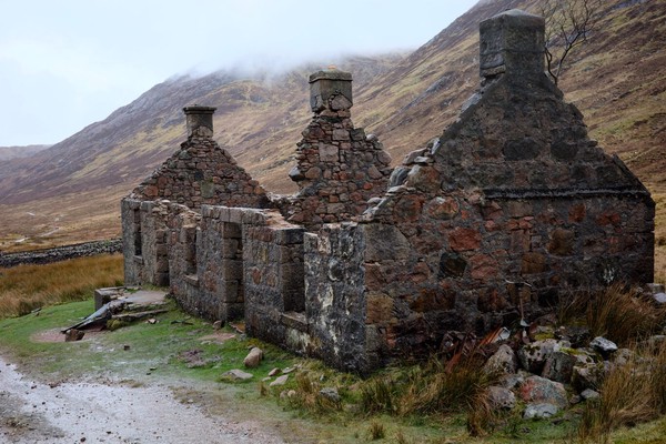
Day 6 - Along a military road near the Devils Staircase. The white structure at center left is officially known as "Lagangarbh Hut" but also as "Wee White House Glencoe".
Camera Model: iPhone 15 Pro
Click for Map Location:N 56.6640194 W 4.8998556
Day 6 - Along a military road near the Devils Staircase. The white structure at center left is officially known as "Lagangarbh Hut" but also as "Wee White House Glencoe".
Day 7#
(Click to see a larger version)

Day 7 - An older marker near an information board. Notice the legs behind the board. The wind was howling and these guys were huddled for a bit of respite behind the board. I joined them.
Camera Model: iPhone 15 Pro
Click for Map Location:N 56.7513556 W 5.1084944
Day 7 - An older marker near an information board. Notice the legs behind the board. The wind was howling and these guys were huddled for a bit of respite behind the board. I joined them.

Day 7 - Near the outskirts of Fort William. The West Highland Way officially shifts toward trafficed roads about 15 minutes after this point.
Camera Model: iPhone 15 Pro
Click for Map Location:N 56.8078306 W 5.0830583
Day 7 - Near the outskirts of Fort William. The West Highland Way officially shifts toward trafficed roads about 15 minutes after this point.

West Highland Way - 2026 - This article is part of a series.
Related
West Highland Way - Day 7 - Kinlochleven to Fort William
West Highland Way - Day 6 - Kingshouse Hotel to Kinlochleven